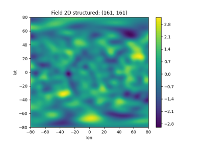
Geographic Coordinates
GSTools provides support for geographic coordinates given by:
latitude
lat: specifies the north–south position of a point on the Earth’s surfacelongitude
lon: specifies the east–west position of a point on the Earth’s surface
If you want to use this feature for field generation or Kriging, you
have to set up a geographical covariance Model by setting latlon=True
in your desired model (see CovModel):
import numpy as np
import gstools as gs

model = gs.Gaussian(latlon=True, var=2, len_scale=np.pi / 16)
By doing so, the model will use the associated Yadrenko model on a sphere
(see here).
The len_scale is given in radians to scale the arc-length.
In order to have a more meaningful length scale, one can use the geo_scale
argument:
import gstools as gs

model = gs.Gaussian(latlon=True, var=2, len_scale=500, geo_scale=gs.KM_SCALE)
Then len_scale can be interpreted as given in km.
A Yadrenko model \(C\) is derived from a valid isotropic covariance model in 3D \(C_{3D}\) by the following relation:
Where \(\zeta\) is the
great-circle distance
and \(r\) is the geo_scale.
Note
lat and lon are given in degree, whereas the great-circle distance
\(zeta\) is given in units of the geo_scale.
Note, that \(2r \cdot \sin(\frac{\zeta}{2r})\) is the chordal distance of two points on a sphere with radius \(r\), which means we simply think of the earth surface as a sphere, that is cut out of the surrounding three dimensional space, when using the Yadrenko model.
Note
Anisotropy is not available with the geographical models, since their
geometry is not euclidean. When passing values for CovModel.anis
or CovModel.angles, they will be ignored.
Since the Yadrenko model comes from a 3D model, the model dimension will
be 3 (see CovModel.dim) but the field_dim will be 2 in this case
(see CovModel.field_dim).